This hike was number 26 in my 52 hike challenge for 2016. To date, I have hiked 264 miles and gained 58458 ft.
Today was a hike to the Mt Falcon Park near Morrison. Morrison is the home the Red Rocks Amphitheater . It is also the namesake for the geologic formation that underlies parts of Colorado, Utah, and the western US. You can find out more about the Morrison Formation here or at this Wikipedia entry.
 |
| Some Red Rocks @ Morrison |
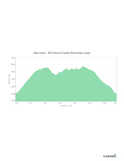
I parked at the east entrance to Mt Falcon Park and headed up the hill. The climb is pretty challenging, about 1600 feet over the first 3.25 miles. While the steepness is not all the great (~8%) the consistent climb and its length make it challenging. This is a popular mountain bike trail. I was passed by several bikers, but later saw a few walking their bikes up the hill. I envy mountain bikers, they are a tough group of folks.
After reaching the top of the mountain, I was treated to the ruins of the John B Walker's home or Castle. John Walker was an interesting man with big dreams. You can find out more about Walker, his dreams, and his life here (a .pdf reader required).
 |
| Information placard on John B Walker |
 |
| Castle Ruins (1) |
 |
| Castle Ruins (2) |
 |
| Castle Ruins (3) |
 |
| Castle Ruins (4) |
I find it interesting that many Colorado mountains host meadows and have relatively flat summit areas. Obviously this is not true of every mountain, but the Mt. Falcon area is a good example. I continued on the Castle Trail to the west parking area, the headed on to the Parmalee Loop. This trail first takes you down the western slope of an unnamed mountain west of Mt Falcon then crosses a intermittent creek and back up to join the Meadow Trail. The trail here was a bit more rustic than the old Stanley Steamer roads around the Castle.
 |
| Parmalee Loop Trail |
 |
| Well worn Stanley Steamer roads to the Castle |
I then continued on to the Meadow Trail, Old Ute Trail, and the Devil's Thumb Loop where I got a nice view, but no picture of Mt Evans. I then headed back to the Tower Trail which takes you to the summit of Mt Falcon where you can climb a tower and have nice 360 degree views of the mountains to the west and the plains to the east.
 |
| Plains to the east early on in the trail (not at the Tower) |
I was pretty much done with this park, so headed back down the mountain to the truck and then on home. I did encounter some deer early on in the trail.
 |
| Deer down low |
 |
| Raven |
On the way down I was met with a spectacular view of the valley between the hogbacks and the mountains south of Red Rocks. The picture doesn't do the view justice.
 |
| Spring time |
All in all another good day!
Overall Track Statistics for Morrison - Mt Falcon Castle Parmalee Loop, 5607 data points
Length 13.597 miles : Garmin Length 0.000 miles
Start Elevation - 6016.08 feet
Maximum Elevation - 7847.77 feet
Minimum Elevation - 5998.16 feet
Date of Hike - May 05, 2016
Start Time - 07:50 AM
End Time - 01:08 PM
Total Duration - 5:18 hours:min
Total Ascent - 4151.44 feet
Total Descent - 4150.98 feet
Net Ascent - 0.46 feet
Maximum Grade - 18.79%
Maximum Ascent over Mile - 706.96 feet
Maximum Speed over Mile - 3.49 mph
Maximum Gain over Mile (%) - 12.43%


No comments:
Post a Comment