My first attempt at plan B was to head to the H-bar-G Ranch near Estes Park and hike to Piper Meadows. Only this past week, I had learned about Piper Meadows and it sounded like a good hike. Since this was plan B, I only had my Trails Illustrated map to go by, but it seemed like it would get the job done. I easily found the road to the H-bar-G trailhead and headed up. It was snowing, the road was narrow, steep, and winding. I got about half way up, put the truck in four wheel drive and continued up the hill. It continued to snow and the road continued to get rougher, so I decided to turn around and come up with plan C. Since I wasn't sure how much snow was going to accumulate today, I decided I didn't want to head down the road in the snow. Hmm, what to do, what would plan C be?
Plan C turned out to be Bobcat Ridge Natural Area. I've been to Bobcat Ridge several times. Once or twice with my friend Galen, once or twice with the grandkids, and nearly a year ago (12/11/2014) on my own. At that time I clockwise hiked the Ginny and D.R. loops around the perimeter of the Natural Area. You can learn a lot about the history of the area at this website (History of Bobcat Ridge area).
 |
| Track from 12/11/2014 hike. |
Because this was plan C, I got a pretty late start (around 10a) and I wasn't sure how far I would go. I didn't have any paper maps of the area, so I picked up a brochure at the trailhead. Not as prepared as I usually am.
Near the junction of the Valley Loop trail and the Powerline trail there is a small area where a tipi once was. My fifth wheel is a bit bigger than that.
 |
| Tipi Ring |
I encountered the usual, "Watch for bears, mountain lions, and rattlesnakes' warning at the trailhead. I didn't see any of those today, but I did encounter quite a few deer and some obnoxious, noisy chipmunks.
 |
| Deer (one of a small group of 8-10 animals) |
The terrain on D.R. trail meanders the ridge lines slowly climbing the hill to Mahoney Park. You seem to be close to the meadow, but then the trail curves around and follows the ridge. This happens at least three or four times. Mahoney Park is a big meadow surrounded by Green Mountain and some lower lying ridge tops. The history claims this is a good area for a variety of wildlife. I didn't see anything today, except a deer or two, but I can see where it would be a good place.
 |
| Mahoney Park |
 |
| Mahoney Park information |
After encountering the D.R, Ginny, Powerline trail junction, I began the gradual climb to Green Mountain. The trail winds its way to the west side of Green Mountain, where you can get some good views of the mountains to the northwest, west, and southwest.
 |
| Look NW from Green Mountain |
 |
| Looking West from Green Mountain |
 |
| Looking SW from Green Mountain. |
Once back and nearing the trailhead, I saw a interesting formation in a tree. What do you think it looks like?
 |
| What is it? |

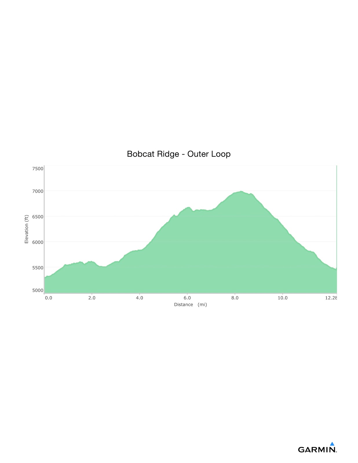
Overall Track Statistics for track Bobcat Ridge - Outer Loop
Length 12.275 miles
Start Elevation - 5290.03 feet
Maximum Elevation - 6988.65 feet
Minimum Elevation - 5289.50 feet
Date of Hike - Oct 30, 2015
Start Time - 09:33 AM
End Time - 02:20 PM
Total Duration - 4:47 hours:min
Total Ascent - 2459.09 feet
Total Descent - 2205.31 feet
Net Ascent - 253.77 feet
Maximum Grade - 14.22%
Average Speed - 2.56 mph
Maximum Ascent over Mile - 554.76 feet
Maximum Speed over Mile - 3.09 mph
Maximum Gain over Mile (%) - 10.21%
No comments:
Post a Comment