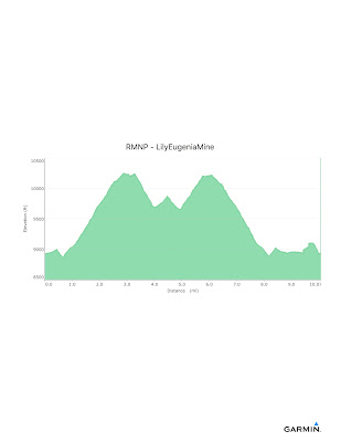
RMNP - Storm Pass (Lily Lake to Eugenia Mine)
I was on the Storm Pass Trail in September 2014, starting at the Storm Pass TH near Sprague Lake and climbing Estes Cone. Today, I started from Lily Lake with the goal of checking out the Eugenia Mine and, maybe, the Longs Peak TH. The weather was supposed to be mixed, temperatures in the mid-30s with a chance of snow later in the day; but the wind would be gusting around 25-30 mph. For once the forecast was accurate.
 |
| Snow at the Lily Lake TH |
This turned out to be a much more difficult hike than I had originally thought. While I knew the climb would be long, I was surprised by the grade. Oh well, it is good for me. The trail was in forest most of the way with limited opportunity for pictures.
This is a sample of the trail conditions. Enough snow for snowshoes. A lot of folks travelled with no snowshoes so the trail was rough with many postholes. That make travel a bit slower.
There is a small meadow near the Moore Park CG with a good view of the Estes Cone. I bet this is a nice spot in the summer.
 |
| Estes Cone |
A little further on is the Eugenia Mine. I think the sign says it all.
 |
| Eugenia Mine |
 |
| Snow! |
 |
| Snow, Snow!! |
 |
| Lily Lake |
Overall Track Statistics for RMNP - LilyEugeniaMine, 1340 data points
Length 10.067 miles : Garmin Length 10.679 miles
Start Elevation - 8920.73 feet
Maximum Elevation - 10246.75 feet
Minimum Elevation - 8850.33 feet
Date of Hike - Feb 29, 2016
Start Time - 09:44 AM
End Time - 03:32 PM
Total Duration - 5:48 hours:min
Total Ascent - 3200.33 feet
Total Descent - 3187.70 feet
Net Ascent - 12.63 feet
Maximum Grade - 20.00%
Average Speed - 1.73 mph : Garmin Average Speed 1.83 mph
Maximum Ascent over Mile - 890.85 feet
Maximum Speed over Mile - 2.64 mph
Maximum Gain over Mile (%) - 14.36%


No comments:
Post a Comment